Laoshan's three main scenic areas offer distinct hiking experiences ranging from challenging summit climbs to peaceful valley walks and cultural temple routes, providing comprehensive mountain adventures that showcase China's most spectacular coastal mountain landscapes. This technical guide provides detailed trail information, GPX downloads, and expert insights for maximizing your Laoshan adventure while ensuring safe, rewarding experiences across all difficulty levels. Whether seeking demanding peak climbs, serene waterfall walks, or cultural temple explorations, these detailed route descriptions enable confident navigation and optimal seasonal planning for unforgettable mountain experiences in Qingdao's natural crown jewel.
Laoshan Trail System Overview
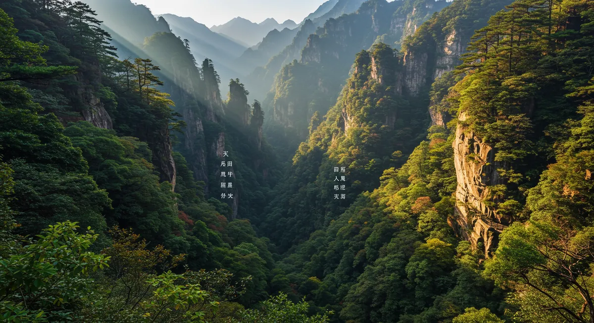
Laoshan's three main scenic areas each offer unique characteristics and experiences, from the dramatic summit views of Jufeng to the waterfall serenity of Beijiushui and the cultural richness of Taiping. Understanding these distinct areas enables optimal planning for fitness levels, interests, and available time.
The mountain's well-maintained trail system includes clearly marked routes, emergency shelters, and regular maintenance that ensures safe hiking conditions throughout most of the year. Each area features different seasonal highlights, from spring wildflowers to autumn foliage, requiring seasonal planning for optimal experiences.
Trail difficulty ranges from easy temple walks suitable for families to demanding summit climbs requiring strong fitness levels and proper preparation. This comprehensive guide provides detailed information enabling confident route selection and preparation for all experience levels.
Jufeng Peak Area (巨峰景区): Summit Challenge
Area Overview and Highlights
Jufeng Peak (1,133m) - The Crown Jewel:
- Significance: Laoshan's highest accessible peak with panoramic coastal views
- Challenge Level: Most demanding of the three areas
- Key Features: Summit views, granite formations, coastal panoramas
- Best For: Experienced hikers seeking challenging summit experiences
- Time Required: 4-6 hours round trip for summit route
- Seasonal Access: Year-round, weather permitting
Main Attractions:
- Jufeng Summit: 360-degree views of Yellow Sea and Qingdao cityscape
- Tianyuan Temple: Mountain temple complex with traditional architecture
- Granite Formations: Spectacular rock formations and natural sculptures
- Sunrise/Sunset Views: Premium vantage points for photography
- Weather Station: Scientific installation near summit area
Jufeng Trail Routes and Descriptions
Route 1: Jufeng Summit Trail (Main Route)
- Distance: 6.2 km round trip
- Elevation Gain: 680 meters
- Difficulty: Challenging (4/5)
- Duration: 4-6 hours total
- Trail Surface: Stone steps, natural rock, some exposed sections
- Key Waypoints: Entrance → Tianyuan Temple → Liuxu Peak → Jufeng Summit
Detailed Route Description:
- 0-1.5km (45 min): Gentle ascent through forest to Tianyuan Temple
- 1.5-2.8km (60 min): Moderate climb to Liuxu Peak viewpoint
- 2.8-3.1km (45 min): Steep final ascent to Jufeng Summit
- Return: Same route with careful attention to steep descents
Route 2: Tianyuan Temple Circuit (Cultural Route)
- Distance: 3.8 km loop
- Elevation Gain: 320 meters
- Difficulty: Moderate (3/5)
- Duration: 2-3 hours
- Highlights: Temple complex, meditation gardens, mountain views
- Best For: Cultural interest with moderate physical challenge
Technical Information and Safety
Equipment Recommendations:
- Footwear: Sturdy hiking boots with excellent grip for rock sections
- Clothing: Layered system for temperature variation with altitude
- Safety Gear: Headlamp, first aid kit, emergency whistle
- Weather Protection: Rain gear and wind protection essential
- Hydration: 2-3 liters water depending on season and route
- Navigation: GPS device or smartphone with offline maps
Safety Considerations:
- Weather Monitoring: Check conditions before departure; avoid in storms
- Rock Conditions: Wet granite extremely slippery; use caution
- Exposure Risk: Summit areas exposed to wind and weather changes
- Emergency Procedures: Know evacuation routes and emergency contacts
- Group Hiking: Recommended for safety and shared experience
Beijiushui Valley Area (北九水景区): Waterfall Paradise
Area Overview and Natural Features
Beijiushui Valley - The Water Garden:
- Character: Gentle valley walk along stream with multiple waterfalls
- Difficulty: Easy to moderate, family-friendly
- Signature Features: Nine major waterfalls, pools, granite gorges
- Best For: Relaxing nature walks, photography, family outings
- Peak Season: Spring through autumn for water flow
- Cultural Element: Traditional Chinese garden aesthetic
The Nine Waters (九水) System:
- First Water: Large pool area with viewing platforms
- Second Water: Small waterfalls with meditation spots
- Third Water: Rock formations and natural sculptures
- Fourth Water: Most photographed waterfall section
- Fifth Water: Deep pools ideal for contemplation
- Sixth-Ninth Waters: Progressive beauty leading to upper valley
Beijiushui Trail Routes
Route 1: Complete Nine Waters Trail
- Distance: 8.4 km round trip
- Elevation Gain: 280 meters
- Difficulty: Easy-Moderate (2-3/5)
- Duration: 3-4 hours with photography stops
- Trail Surface: Paved paths, wooden walkways, stone steps
- Accessibility: Suitable for most fitness levels
Detailed Walking Description:
- 0-1.2km (20 min): Entrance area to First Water viewing area
- 1.2-2.8km (40 min): First to Fourth Waters - main waterfall sections
- 2.8-4.2km (50 min): Fifth to Ninth Waters - upper valley exploration
- Return: Same route with different perspectives on descent
Route 2: Waterfall Photography Circuit
- Distance: 5.6 km round trip
- Focus: First through Sixth Waters - best photography locations
- Duration: 2-3 hours with extended photo time
- Best Times: Early morning soft light, late afternoon golden hour
- Equipment: Tripod recommended for long exposure water shots
Seasonal Considerations and Best Times
Spring (March-May):
- Water Flow: Excellent from snowmelt and spring rains
- Vegetation: Fresh green foliage and wildflowers
- Weather: Mild temperatures, variable conditions
- Crowds: Moderate, increasing toward summer
- Photography: Excellent for fresh green landscapes
Summer (June-August):
- Water Flow: Good to excellent, depending on rainfall
- Temperature: Cool in shaded valley areas
- Crowds: Peak season with significant visitor numbers
- Best Strategy: Early morning or evening visits
- Swimming: Some pools suitable for cooling off
Autumn (September-November):
- Foliage: Spectacular autumn colors throughout valley
- Water Flow: Reduced but still attractive
- Weather: Crisp, clear days ideal for hiking
- Photography: Peak season for landscape photography
- Crowds: Moderate, excellent hiking conditions
Taiping Palace Area (太平宫景区): Cultural Heritage
Historical and Cultural Significance
Taiping Palace - Spiritual Heart of Laoshan:
- Historical Importance: 1,000+ year Taoist temple complex
- Cultural Value: Active religious site with traditional practices
- Architecture: Classical Chinese temple design in mountain setting
- Spiritual Atmosphere: Peaceful environment for contemplation
- Educational Value: Insights into Chinese religious and philosophical traditions
- Accessibility: Most accessible of the three main areas
Key Cultural Sites:
- Main Palace Complex: Central temple buildings and courtyards
- Meditation Gardens: Traditional Chinese garden design
- Ancient Trees: Centuries-old specimens with cultural significance
- Stone Inscriptions: Historical calligraphy and poetry
- Prayer Areas: Active worship spaces for visitors and pilgrims
Taiping Palace Trail Routes
Route 1: Palace Complex Circuit
- Distance: 2.8 km loop
- Elevation Gain: 150 meters
- Difficulty: Easy (1-2/5)
- Duration: 1.5-2 hours
- Trail Surface: Paved paths, stone steps, garden walkways
- Cultural Focus: Temple architecture, gardens, spiritual sites
Route 2: Extended Cultural Walk
- Distance: 4.6 km
- Highlights: Palace complex plus surrounding cultural sites
- Duration: 2.5-3 hours with cultural exploration
- Educational Value: Comprehensive cultural and historical experience
- Best For: Cultural interest, photography, peaceful contemplation
Cultural Etiquette and Guidelines
Temple Etiquette:
- Dress Code: Modest clothing covering shoulders and knees
- Behavior: Quiet, respectful conduct throughout temple areas
- Photography: Ask permission before photographing people or ceremonies
- Religious Respect: Understanding significance of spiritual practices
- Donation Protocol: Optional donations in designated areas
- Incense Etiquette: Proper procedures if participating in rituals
GPX Downloads and Navigation
Digital Trail Resources
GPX File Downloads:
- Jufeng Summit Route: Complete GPS track with waypoints
- Beijiushui Valley Trail: Nine Waters route with photo locations
- Taiping Palace Circuit: Cultural route with temple sites marked
- Combined Routes: Multi-day exploration tracks
- Emergency Routes: Evacuation and alternative paths
- Format Compatibility: Files compatible with major GPS devices and apps
Navigation Tools and Apps:
- Offline Maps: Download maps before visiting for reliable navigation
- GPS Coordinates: Key waypoints for major locations
- Emergency Locations: Shelter and help point coordinates
- Trail Markers: Understanding physical trail marking system
- Weather Updates: Apps for current mountain weather conditions
Technical Navigation Information
GPS Coordinates (Key Locations):
- Jufeng Entrance: 36.1789°N, 120.6123°E
- Jufeng Summit: 36.1801°N, 120.6089°E
- Beijiushui Entrance: 36.1456°N, 120.5967°E
- Ninth Water: 36.1523°N, 120.5845°E
- Taiping Palace: 36.1634°N, 120.6234°E
- Emergency Shelter: 36.1767°N, 120.6045°E
Multi-Day and Combination Routes
Advanced Hiking Options
Two-Day Laoshan Experience:
- Day 1: Jufeng Summit challenge with overnight accommodation
- Day 2: Beijiushui Valley relaxation and Taiping Palace culture
- Accommodation: Mountain guesthouses and nearby hotels
- Transportation: Coordinate between areas via local transport
- Equipment: Overnight gear and extended hiking supplies
Complete Laoshan Circuit (Advanced):
- Distance: 18-22 km depending on routes selected
- Duration: 2-3 days with proper pacing
- Difficulty: Challenging (4-5/5)
- Planning: Requires detailed preparation and support
- Permits: Check requirements for extended hiking
- Experience Level: Advanced hikers only
Combination Day Trips
Waterfall and Culture Combo:
- Morning: Beijiushui Valley waterfall walk (3 hours)
- Afternoon: Taiping Palace cultural exploration (2 hours)
- Total Time: 6-7 hours including transport and breaks
- Best For: Moderate fitness levels seeking variety
- Transport: Convenient connections between areas
Seasonal Planning and Conditions
Best Hiking Seasons
Peak Season (April-June, September-November):
- Weather: Mild temperatures, stable conditions
- Visibility: Clear days with excellent mountain views
- Trail Conditions: Optimal conditions on all routes
- Crowds: Higher visitor numbers but manageable
- Photography: Excellent lighting and conditions
Shoulder Season (March, July-August, December):
- Considerations: Variable weather, plan flexibility required
- Advantages: Fewer crowds, potential for excellent conditions
- Preparation: Extra weather protection and planning needed
- Rewards: Unique seasonal beauty and peaceful experiences
Weather and Safety Monitoring
Pre-Trip Planning:
- Weather Forecasts: Check 3-day forecasts for mountain areas
- Trail Conditions: Contact park services for current trail status
- Seasonal Closures: Some trails may close during extreme weather
- Emergency Preparedness: Always prepare for weather changes
- Communication Plans: Establish check-in procedures with others
Equipment and Preparation
Essential Hiking Gear
For Jufeng Peak (Challenging Routes):
- Footwear: Sturdy hiking boots with ankle support
- Clothing: Layered system including waterproof outer shell
- Safety: Headlamp, first aid kit, emergency whistle, GPS device
- Comfort: Trekking poles, comfortable backpack, sun protection
- Hydration: 2-3 liters water, electrolyte supplements
- Nutrition: High-energy snacks, lunch for long routes
For Beijiushui and Taiping (Moderate Routes):
- Footwear: Comfortable hiking shoes with good traction
- Clothing: Comfortable layers, rain protection
- Basics: Water, snacks, camera, small first aid kit
- Comfort: Lightweight daypack, sun hat, comfortable walking gear
Physical Preparation
Fitness Recommendations:
- Jufeng Summit: Good cardiovascular fitness, leg strength
- Beijiushui Valley: Basic walking fitness, no special preparation needed
- Taiping Palace: Minimal fitness requirements
- Training: Regular walking or hiking preparation beneficial
- Health Considerations: Consult healthcare providers for existing conditions
Transportation and Access
Getting to Trail Areas
Public Transportation:
- Bus Routes: Regular services from Qingdao city center
- Schedules: Plan return transport before departing
- Costs: Affordable public transport options
- Reliability: Generally punctual and frequent service
Private Transportation:
- Taxi Services: Direct transport to trail entrances
- Ride-Sharing: DiDi and other apps available
- Rental Cars: Flexibility for multi-area exploration
- Tour Groups: Organized transport with guided options
For comprehensive transportation information, consult our detailed transport guide.
Photography and Documentation
Best Photography Locations
Jufeng Peak Photography:
- Summit Views: 360-degree panoramas of coast and city
- Sunrise/Sunset: Dramatic lighting on granite formations
- Rock Formations: Unique geological features and textures
- Weather Drama: Clouds and mist creating atmospheric conditions
Beijiushui Valley Photography:
- Waterfall Techniques: Long exposure for smooth water effects
- Seasonal Changes: Spring flowers, summer green, autumn colors
- Reflection Pools: Mirror effects in calm water sections
- Wildlife Opportunities: Birds and small mammals in natural habitat
Documentation and Sharing
Trail Documentation:
- GPS Tracks: Record routes for future reference
- Photo Geotagging: Location information for photo organization
- Condition Notes: Trail and weather conditions for others
- Timing Information: Actual hiking times for planning
- Safety Observations: Note any hazards or concerns
Connecting with Other Qingdao Adventures
Laoshan's trail system integrates perfectly with broader Qingdao exploration, offering mountain adventures that complement coastal experiences and alternative hiking opportunities. These diverse routes provide options for every fitness level while showcasing the natural diversity that makes Qingdao unique among Chinese coastal destinations.
Plan comprehensive mountain adventures using our general Laoshan guide, and discover how technical trail knowledge enhances safety and enjoyment in this remarkable mountain landscape that defines Qingdao's natural heritage.